My Tide Times - Tables & Chart
- 4.8
- Rating
- 1.00M
- Installs
- Free
- Price

 Analysis by App-foxy
When I need to know whether the sea will be practical for a walk, a launch, fishing, or a day beside the harbour, I want something more useful than a general weather icon. My Tide Times focuses on the part of coastal planning that ordinary weather apps often treat as an afterthought: the rise and fall of the tide. I found it most valuable when I already knew where I was going and needed a quick answer about timing, rather than a broad forecast for the entire day.
This is a free weather app from JRustonApps B.V., aimed at anyone who follows local tide tables and forecasts. It has built a strong reputation, with a 4.8 average from around 27,000 ratings, and it has passed the million-install mark. Those figures do not replace personal testing, but they do suggest that the app has become a familiar tool for a substantial number of coastal users.
My overall impression is positive, with one important qualification: this is a focused tide companion, not a complete marine-navigation system or a substitute for local judgement. Its strength is helping me read tidal timing quickly. Its weakness is that people expecting detailed sailing instruments, a full coastal weather suite, or extensive trip-planning tools may find the experience narrower than they want.
You May Also Like

 Blood Strike: 2.5 Anniversary
Blood Strike’s Loadouts Turn Every Drop Into a Tactical Gamble
A close look at Blood Strike’s custom loadouts: how fast access to signature weapons reshapes its battle royale rhythm, rewards preparation, and narrows the gap between fights.

 Pandora - Music & Podcasts
Pandora’s Music Is Easy to Start, but Harder to Recover
Pandora’s strength is its low-effort path from a seed to a station. Its weak spot is how much confidence it asks you to place in connection, setup, and quiet recovery.

 8 Ball Pool
 Is Built on Rivalries, Rematches, and Routine
A close look at the rivalries, rematches, shared routines, and unanswered safety questions that turn a quick pool match into a persistent mobile community.

 Samsung Music
’s Quiet Strength Is Playing What You Already Own
Its reach comes less from spectacle than from dependable access to a personal library. That simplicity is both the app’s strongest retention engine and its ceiling.

 AccuWeather: Weather Radar
AccuWeather Review: A Quick, Clear Forecast for Everyday Decisions
For everyday plans, the best forecast is the one you can understand quickly. AccuWeather makes rain timing, radar, and local conditions easy to act on, with a few trade-offs.

 Hill Climb Racing
Why Hill Climb Racing Still Turns Crashes Into One More Run
A tiny car, a bumpy hill and one more upgrade: Hill Climb Racing keeps resurfacing because its simple chaos makes every near-miss feel personal.
More From Our News Desk



How the tide-focused approach feels in daily use
In daily use, I find the tide-first approach most helpful when I have a specific shoreline activity in mind: it shifts planning from a vague weather check to the timing that can shape access and comfort. I’d start by choosing the station that best represents the destination, then use the curve to leave a practical buffer around the outing. That routine also makes it easier to judge how the app holds up when plans get more involved.
A clearer answer than a general weather forecast
The main benefit is concentration. Most weather applications put temperature, rain, wind, and alerts first. Those details matter, but they do not tell me when a beach will be accessible, when a shallow channel may become difficult, or whether a shoreline walk will line up with the water level I want. A dedicated tide app changes the question from “What will the weather be?” to “What will the water be doing at this place and time?”
That distinction makes the app especially useful for recurring coastal routines. I can imagine opening it before taking a small boat out, checking it before photographing a rocky shoreline, or using it while planning a fishing session around the changing water. It also suits less technical situations. Someone arranging a family beach visit may not need nautical terminology; they may simply want to avoid arriving at the wrong part of the tidal cycle.
The app’s store summary calls it a complete tide-table and forecast application, but I would interpret that promise sensibly. It is complete in the sense of being built around tide information rather than being a general-purpose weather dashboard. I would not treat it as a single source of truth for every risk on the water. Wind, visibility, swell, currents, local restrictions, and conditions at the actual launch point still deserve separate attention.
Reading the chart instead of guessing from a clock
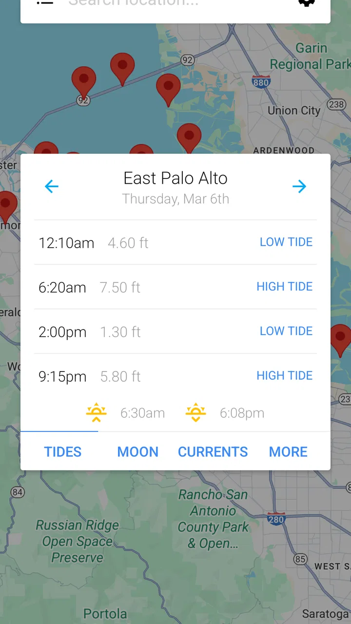
The chart is more useful than a simple list of times because it gives the tide a shape. A list can tell me when high and low water occur, but a visual curve helps me understand how quickly the level is changing around those points. That matters when a narrow window is important. The difference between arriving just before a turning point and arriving during a faster change can affect a shallow landing, a mudflat crossing, or a photography location.
My practical tip is to avoid checking only the next high or low tide. I would look across the whole day, then compare the timing with the activity itself. A walk that takes an hour needs a different plan from a quick shoreline stop. For a boat outing, I would also leave room for preparation, launching, returning, and unexpected delays instead of treating a displayed tide time as a hard appointment.
This is one of the app’s less obvious strengths: it encourages planning around a pattern rather than a single number. That makes it more useful for people who are learning how tides behave at a familiar location. After checking the same area over several outings, the chart can become a quick visual reference for deciding whether the conditions fit the plan.
Choosing the right place is more important than choosing the right day
Tide information is highly local. A forecast for a nearby harbour may not be a safe stand-in for an exposed beach, an estuary, or a different side of a headland. I would therefore spend more care selecting the station than I would spend admiring the chart. If the app offers several nearby locations, I would compare them with the exact place I intend to visit rather than automatically accepting the first result.
This is a useful workflow for unfamiliar coastlines: first identify the beach, harbour, river mouth, or launch area; then check whether the selected tide station actually represents that environment; finally compare the displayed times with local signs and any information from the harbour or coast authority. The app can make the first two steps faster, but it cannot remove the need for local knowledge.
That location issue is also where a general weather app sometimes feels easier. Weather services are usually designed around a familiar town or current location, while tide planning may require more deliberate station selection. For a user who only wants a quick rain forecast, this extra step may feel like friction. For a coastal user who understands why the station matters, it is a worthwhile part of the process.
A realistic morning with the app
Consider a simple Saturday plan. I want to walk along a beach with a section that becomes awkward near higher water. Before leaving, I would select the relevant coastal station, inspect the day’s high and low points, and note when the water is moving toward the level that affects the route. I would then check the ordinary weather forecast separately for rain and wind, add travel time, and choose a return point that does not depend on perfect timing.
On arrival, I would not assume that the app’s forecast overrides what I can see. Waves, debris, erosion, local currents, and access restrictions can change the practical situation. The app helps me make a better plan before setting out; it does not turn a changing shoreline into a predictable one. That is the right relationship to have with it.
Where it sits beside other weather and marine tools
Compared with a standard weather app, this application gives tidal information the attention it deserves. It is a better choice when the water level determines the activity. A general weather service remains better for an all-in-one daily forecast, especially when I need radar, severe-weather information, wind details, or a broad view of conditions away from the coast.
Compared with specialist marine software, the trade-off is simplicity. A serious sailor may need navigation features, route planning, chart layers, current predictions, or vessel-specific information. I would look elsewhere for those needs. My Tide Times makes more sense as a fast reference for tide tables and charts than as the central instrument for a complex passage.
It also complements rather than replaces official local sources. When a harbour authority, lifeguard service, or local coastal organisation provides a warning, closure, or safety instruction, that information takes priority. I see this app as a convenient planning layer: it helps me organise the timing, while local notices explain the conditions and restrictions that a tide curve alone cannot show.
Trust, permissions, and what I would check before relying on it
Because tide planning can influence a real outing, I care about trust in a practical way. I want to know what the app asks me to allow, whether I can choose a location myself, and whether I can continue using the core information without handing over more control than necessary. The most responsible habit is to review the permission prompts on the device rather than approving them automatically.
If I am searching for a known harbour, I would prefer selecting it directly when that option is available instead of relying on automatic location. Manual selection gives me a chance to verify the station and reduces the risk of silently using a nearby place that is not representative of my destination. If I do enable location access, I would make that decision because it saves time, not because a tide table requires blind trust.
I would also inspect the app’s visible settings and the platform’s privacy controls before making it part of a regular routine. The important question is not whether an app sounds reassuring; it is whether I can see and manage the choices that affect my use. I would pay attention to notification settings, location access, account prompts, and any controls related to stored preferences. If a feature is not needed for my workflow, I would leave it off.
The same caution applies to account control. I would not create an account merely to look up a tide time unless the app clearly explains why it is needed and what benefit it provides. A focused reference tool should fit into my routine without making me surrender unnecessary personal information. If I later stop using it, I would remove permissions I no longer need and uninstall it through the normal device controls.
Data-sensitive moments during coastal planning
Location is the sensitive moment here. A tide app can be convenient when it recognises where I am, but a coastal location may reveal where I live, work, fish, launch, or spend leisure time. I would use location only when the convenience is meaningful, and I would avoid treating automatic detection as more accurate than checking the station name myself.
Another sensitive moment is sharing a screenshot or plan with someone else. A chart may seem harmless, yet a saved location or repeated pattern can reveal a favourite fishing spot or a regular routine. Before sharing, I would check whether the image includes a precise station name or other personal context. For a family outing, I would share the meeting details rather than my entire history of saved coastal locations.
I would take similar care with notifications. Tide reminders could be useful for a scheduled outing, but unnecessary alerts quickly become noise. My preference would be to enable only the reminders that support a real plan, then review them after the trip. This keeps the app helpful without allowing it to become another source of constant prompts.
There is also a safety-sensitive data issue: forecasts are predictions, not guarantees. Even an accurate tide table cannot describe every local hazard. If an activity involves exposed rocks, strong currents, a small craft, or a remote route, I would cross-check official warnings and the weather before leaving. The app earns my trust when I use it within those limits, not when I ask it to answer questions it was not designed to answer.
Useful habits that make the app more reliable
Check the station before checking the time. I would confirm that the selected location matches the actual shoreline, harbour, or launch point. This is more important than memorising a displayed high or low tide.
Read the curve around the event. I would look at the hours before and after high or low water so I can judge how the tide is changing during the activity, not just when it turns.
Build in a buffer. I would avoid planning a route that works only if I arrive at one exact minute. Travel, parking, preparation, and changing conditions all consume time.
Separate tide planning from weather planning. I would use this app for the tidal question and a trusted weather source for wind, rain, visibility, and warnings. Combining both checks gives me a more realistic picture.
Review permissions occasionally. If I stop using automatic location or notifications, I would turn them off. User control is easier when I treat permissions as choices to revisit rather than permanent approvals.
Who will appreciate it, and who should skip it?
I would recommend it to beach walkers, anglers, coastal photographers, paddleboarders, small-boat users, campers near tidal areas, and anyone who regularly plans around the shoreline. It is also a sensible learning tool for newcomers who want to understand the rhythm of a local coast without starting with a complex marine application. The visual presentation can make the relationship between time and water level easier to grasp than a bare table.
I would be more cautious about recommending it as the only app for offshore sailing, technical navigation, or activities where currents and official warnings are central. In those situations, a specialist marine tool and local authority information may be more appropriate. I would also skip it if I rarely visit the coast and only need temperature, rain, or storm alerts; a conventional weather application would probably serve that purpose more efficiently.
The free price makes trying it straightforward, and the Everyone content rating means it is presented for a broad audience. It supports a low-commitment test: choose a familiar location, compare the chart with what you already know, and see whether the workflow fits your habits. I would judge it on that practical trial rather than on the popularity figures alone.
Version, compatibility, and the everyday experience
The current version is 26.2.0, and the app supports devices running Android 7.0 or later. That makes it accessible to many older Android phones, which is useful for a tool I might keep on a spare device used for outdoor trips. Still, compatibility is only the starting point. A coastal app needs to remain readable in bright light, quick to open when I am outside, and simple enough to use when I am carrying equipment or wearing gloves.
I would test those practical details before a demanding trip. I would open the app at home, select the destination, review the relevant day, and make sure I understand what the chart is showing. That preparation avoids trying to learn the interface beside the water, where poor reception, glare, cold, or limited battery can make small inconveniences much bigger.
I also would not depend on any phone app as my only plan in a remote area. A screenshot or written note of the important tide window can be useful, but I would still carry the equipment and information appropriate to the activity. The app is most effective when it reduces planning effort before departure, not when it is treated as an emergency device.
My cautious verdict
After using it as a tide-planning companion, I see a clear reason to keep it installed: it gives the changing water level a dedicated place in my routine. The charts help me think in terms of timing and progression, while the focused design avoids burying the information under unrelated weather details. For ordinary coastal planning, that is a meaningful advantage.
My recommendation comes with boundaries. I would verify the station, review the displayed choices and permissions, cross-check weather and official warnings, and leave a sensible margin around every plan. I would not use it to replace navigation knowledge or local safety advice. Those limits are not flaws unique to this app; they are part of using any forecast responsibly.
If your plans regularly depend on the tide, this is a practical free tool worth trying. It is less convincing for users seeking a complete weather dashboard or professional marine-navigation suite, but its focused purpose is exactly why I would recommend it to a friend who keeps asking when the beach, harbour, or shoreline will be at the right stage of the tide.
Developed by JRustonApps B.V., My Tide Times has the maturity and broad audience suggested by its long availability since January 22, 2014, its million-plus installs, and its strong user response. I would still make my own permission and safety choices, but for clear tide tables and visual planning on a compatible Android device, it earns a place in my coastal toolkit.
FAQs for My Tide Times - Tables & Chart
01What features does My Tide Times offer?
My Tide Times provides detailed tide times and tide charts for over 9,000 locations worldwide. It offers sunrise, sunset, moonrise, and moonset times, along with a 7-day weather forecast. Users can customize favorite locations for easy access and receive notifications about important tide changes.
02Is My Tide Times available on both Android and iOS?
Yes, My Tide Times is available for download on both Android and iOS platforms. You can easily find it in the Google Play Store for Android devices and the Apple App Store for iOS devices, ensuring compatibility and seamless user experience across different operating systems.
03How accurate is the tidal information provided by My Tide Times?
My Tide Times uses data sourced from reliable organizations such as the National Oceanic and Atmospheric Administration (NOAA). This ensures high accuracy of tidal information. However, users should be aware that environmental factors can occasionally affect tide predictions, so it’s always wise to verify with local sources.
04Does the app require an internet connection to access tidal data?
While My Tide Times requires an internet connection for initial data downloads and updates, it can store data locally on your device. This allows you to access previously downloaded tide information without needing an internet connection, which is useful for locations with limited connectivity.
05Can I set alerts for specific tide events?
Yes, My Tide Times allows users to set custom notifications for specific tide events. This feature is particularly useful for planning activities such as fishing, surfing, or boating, where specific tide conditions are crucial. Users can easily configure alerts through the app settings.
Pros
- Accurate tide predictions worldwide.
- User-friendly interface and navigation.
- Customizable alerts for tide changes.
- Offline access to saved locations.
- Includes sunrise and sunset times.
Cons
- Ads can be distracting at times.
- Limited features in the free version.
- No detailed weather forecasts.
- Some locations may load slowly.
- Requires periodic data updates.

My Tide Times - Tables & Chart
Gallery